This publication has been produced with the assistance of the European Union. The contents of this publication is the sole responsibility of the authors and can in no way be taken to reflect the views of the European Union.
Suojärvi District lies within the mid-taiga subzone, but its northern border roughly coincides with the southern boundary of northern taiga. The territory generally falls within the Central Karelian denudation plain limits, only its very north-western reaches representing southern ridges of the West Karelian upland. The matrix landscapes are morainic and abrasion-accretion plains with frequent compact glacio-aqueous deposits (eskers, kames, drumlins). Generally dominant features are low ridges and hills, and major Quaternary sediments are sands and sandy loams. The prevalent types of soils in dry areas are ferro-humic sandy and sandy loam bouldery podzols, and in wet areas - peaty transitional and bog soils. The degree of paludification (open mires and swamp forests) varies widely (20 to 60%) with an average of c. 30%.
Tectonic denudation hilly-ridge heavily or moderately paludified landscapes dominated by pine habitats prevail in most of the territory. Landscapes of this type occupy nearly a half of all Karelia.
The most general traits of the landscapes are:
diverse, predominantly hilly-ridge topography, often with large uplands and isolated bedrock outcrops;
regionally average density of the watercourse network and length of lake shoreline;
paludification degree typical of taiga regions, where dry areas are broken into small fragments by open mires of variable size;
clear prevalence of pine forests, often interspersed with small spruce stands, mostly in depressions between ridges and hills;
prevalence of the true-moss group of forest types (bilberry and cowberry types) with fragments of pine stands on dry sandy hills and ridges.
Landscapes were distinguished using the earlier developed classification and map based on the zonal typology principle (Volkov et al., 1990, 1995). Landscape contours were drawn with regard to genetic landforms and Quaternary deposits, paludification degree and prevalent types of forest habitats determining climax communities (tab., colour and monochrome maps). Spatially isolated landscape contours with similar characteristics of all the classifying parameters were clustered into the "landscape type" category. Zonally, they were differentiated into the mid-taiga and north-taiga ones.
Table 1. Classification of taiga landscapes of Karelia
Prevalent habitat types (by climax communities)
Paludification degree
heavy > 50%
moderate 20-50%
low < 20%
I. Lacustrine, glaciolacustrine and marine (М) plains
Spruce
1/1.5*
2/4.0
Pine
3/8.5
4/2.0
5/+**
II. Glacial (Л) and glacio-aqueous (ВЛ) hilly-ridge
Spruce
6/4
Pine
7/5.0
8/4.5
9/1.0
III. Glacial accretion, complex terrain
Spruce
10/2.5
Pine
10/2.5
IV. Tectonic denudation, hilly-ridge with a complex of glacial formations (Л) and low-montane (Г)
Spruce
12/12.5
Pine
13/8.0
14/37.5
V. Tectonic-denudation, ridge (selka)
Pine
15/+
16/1.0
Сосновые
17/2.5
18/1.5
VI. Rocky
Pine
19/1.0
20/0.5
* - landscape number in the numerator, its area in Karelia - in the denominator
** - less than 0.5%.
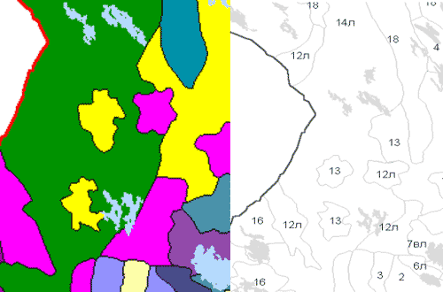
Name of the geographical landscape type (number and colour in the maps): 1. lacustrine and glaciolacustrine, moderately paludified plains dominated by spruce habitats (N 2, light blue);
2. lacustrine and glaciolacustrine, heavily paludified plains dominated by pine habitats (N3, light yellow);
3. glacial, hilly-ridge, moderately paludified, dominated by spruce habitats (N6л, dark blue);
4. glacio-aqueous, hilly-ridge, heavily paludified, dominated by pine habitats (N7вл, lilac);
5. glacio-aqueous, hilly-ridge, moderately paludified, dominated by pine habitats (N8вл, cyan);
6. (N12л, pink);
7. tectonic denudation, hilly-ridge, heavily paludified, dominated by pine habitats (N13, dark yellow);
8. tectonic denudation, with complexes of glacial formations, hilly-ridge, moderately paludified, dominated by pine habitats (N14л, green);
9. tectonic denudation, ridge (selka), little paludified, dominated by pine habitats (N18, blue).