The Suojärvi District has a ramified drainage network belonging to the Baltic Sea watershed. It is only in the utter north-east that a small area belongs to the White Sea drainage basin (Lake Segozero - Baltic-White Sea canal). Within the Baltic Sea watershed, the district is situated on a drainage divide, which largely determines the specific characteristics of its waters. One of Karelia's largest drainage divides - between Lake Onego and Ladoga watersheds - cuts the district territory roughly into two. Lake Onego receives drainage from the eastern part along the Shuja and Suna lake-river systems, Lake Ladoga - from the western part along the Vuoksa lake-river system via Finland and from the southern part - directly into the lake via its northern influents.
The drainage network is composed either of small rivers, or of relatively short channels which connect numerous lakes to form lake-river systems. The channel depth and flow rate range widely in different parts of the rivers: flow rates may reach 4-5 m/sec in rapids, but drop nearly to zero in deeps and lake-like openings. Depths range from 0.1 m in rapids to 10 m in deeps. Drainage divides are normally not high, paludified, inexplicit. The main watercourses are rivers Suna (total length 280 km), Shuja (194), Tarasjoki (72 km).
Rivers belong to the category with the spring flood, typical for the Karelian hydrographic region. Recharge is from mixed sources, mostly from snowmelt. Monthly runoff is the greatest in May (20-40% of the annual sum total), and the lowest - in March (0.6-3.5%).
The spring flood normally begins on April 20-25 and lasts 70 to 100 days on larger rivers with high lake coverage, and 50 to 70 days - on small rivers. Rainfall floods occur in the warm part of the year only. Maximum discharges at rainfall floods are usually lower than maximum discharges of the spring flood.
Streamflow drops to a minimum twice a year - in the summer-autumn and the winter low water periods. The summer-autumn low water period commonly begins in late June - middle July and is over by late September - early October. It lasts 65-70 days. The winter low water period usually commences in late November - middle December. Its average duration is 115-130 days. The lowest winter and yearly discharges are recorded in late March - early April. They are nearly twice lower than the minimum discharge of the summer-autumn low water period.
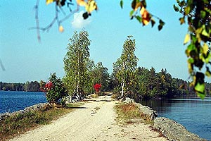
Fig. 2. Road across the Tolvajärvi lake-river system |
Lakes differ widely in their morphometric characteristics. The largest ones (Sjamozero - 266 km2, Janisjärvi - 200, Gimolskoye - 80.5 km2) are situated at the district border. Other significant lakes are Suojärvi (58.5 km2), Salonjärvi (46.1), Jangozero (32.8), Viksinselkä (31.6), Loimolanjärvi (28.3), Ala-Vieksjärvi (28.2), Royknavolotskoye (25.1 km2), etc.
The annual cycle of the level of medium and small lakes comprises a distinct spring rise. The level reaches the highest point in May-June, after the lakes free of ice. An autumn rise of the level caused by heavy rainfall is also observed in lakes of the district. The summer minimum on medium lakes is in September, on small lakes - in July-August. The winter fall to the lowest annual level occurs in March-April. Level fluctuations in medium lakes are within 1.5 m, whereas in small lakes they may be over 3 m.
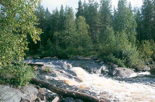
Fig. 3. River rapids
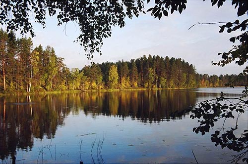
Fig. 4. A typical forest lake
Expert: A. Litvinenko
Photos by: I. Georgievsky
|